 |
Mt. Washington Temp.
Click pic for forecast.
| ...More Topics... |
 Books Books |
| Bulletin Board |
| Clubs & Huts - AMC Huts |
| Feedback |
| 4,000 footers |
| Hiking Glossary |
| Mail List |
| Privacy Policy |
| Store |
| Weather |
| Search |
|
|


![]()
![]()


Crawford Connector to the Crawford Path to the Mt. Eisenhower loop to Edmands Path
by Chris
 |
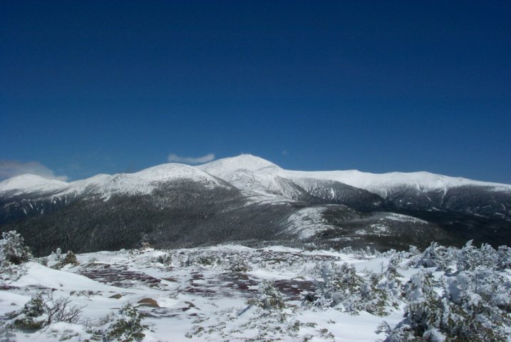 |
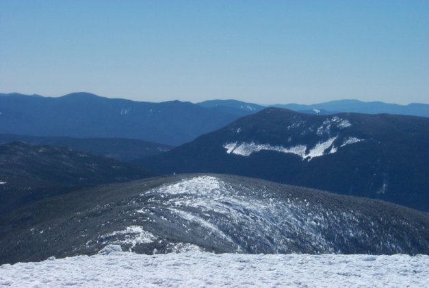
| Mt Pierce as seen from Mt. Eisenhower | Mt. Eisenhower with Washington, Clay, Jefferson, and Monroe in the background |
It had been a whole two weeks since I was able to hike, so I thought I'd better get out again. Ok, maybe that's a little bit of an exaggeration - I had been watching the forum and saw that several of my online buddies were planning a day in the Whites, and I thought it would be an excellent idea to join them.
By the time the date arrived, the group planning to go consisted of MtnMagic (with GhostDog of course), New Hampshire (Brian) and Jen (Brian's sister). A nice small group, which was perfect in my mind. The plan was to meet at the trailhead at 10:00 AM, spot a car and drive over to the Edmands Path trailhead (the Clinton Rd was open). However, a quick look at the Mt. Clinton Rd showed a decent amount of snow, which neither Brian nor Magic thought their car would do well in, so we altered our plan and decided to walk up the Crawford Path to Pierce, then Eisenhower and reverse course to return to the Crawford parking area. It wasn't the loop we'd hoped for, but it would do.
We started out on the Crawford Connector, a short path out of the Crawford parking lot that naturally connects to the Crawford Path (the oldest continually maintained footpath in the country). The Crawford Connector crosses over the Mt. Clinton Rd, which is where we saw a very cold hiker with a homemade walking stick. Within 200 yards we crossed over the Gibbs Brook and reached the junction of the Crawford Path. It was at this point that we were asked by a speed hiker, "uhh, dumb question, but is this the Crawford Path?" I managed not to answer with a very sarcastic "noooooo, you're WAY off!" and he went on his merry way.
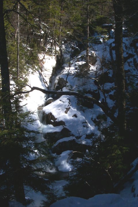
One look at the topo of this hike and one can see the moderate grade of the trail. Magic was leading the way and set a very comfortable pace over a well packed trail. Within a few minutes, we reached Gibbs Falls and the short spur that leads to the falls. I informed the group that this was a "photo op" and took a well-advised detour to see Gibbs Falls. Let me just assure the reader that this is a must-see on this hike. The falls are gorgeous and though it's measured at 40 feet tall, the area just above the fall is steep enough to make it look more like 80 feet.
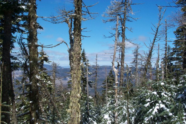
Despite the beauty of the falls, we were all eager to get moving again, so we pressed on. Continuing on the moderate grade our group warmed up quickly and made good time. Before long we all shed a layer and shifted into "cruise" mode. At about 1.7 miles, we had gained enough altitude to see over the slight ridge that parallels the trail and caught our first tree-obscured views of Monroe, Washington, Jefferson and Eisenhower. This energized me, and Magic assured us that greater views were just ahead. At 1.9 miles (about 2/3 of the way to Mt. Pierce), we reached the Mitzpah Cutoff. We had no interest in the Mitzpah Hut, so we bore left and made the push towards the summit.

At this point, the snow was a little deeper on the trail and crampons would probably have helped in a couple of places, but footing was stable enough that we didn't find them necessary. A group ahead of us was breaking trail nicely; the region had received about 16" of snow three days earlier. At about 3.0 miles, the trail reaches a plateau where some absolutely spectacular views of the valley and Presidentials can be had. Everyone's already cheerful mood increased immediately with the sights we were taking in.
The wind soon began to pick up and cool us all down. At 3.1 miles we met the Webster Cliff Trail which leads to the summit of Pierce after only .1 mile. The summit is wide open despite some low trees and can hold a large group of people. We chose to have a quick snack, take some pictures and get on our way. The wind was strong enough to cool us considerably unless we bundled up, and Magic said it best when he asked, "Everyone ready to go to the better peak?" We were, so we made the quick return to the Crawford Path, where it now becomes part of the Appalachian Trail, and were on our way again.
At 4,312 feet, Pierce isn't high enough to be out of the trees, which in this case was a blessing. As we moved along the ridge the wind was on-again, off-again making conditions alternately wintry, then spring-like. This made it tough to dress appropriately, so I just went with a lighter layering and sucked it up when the wind blew.
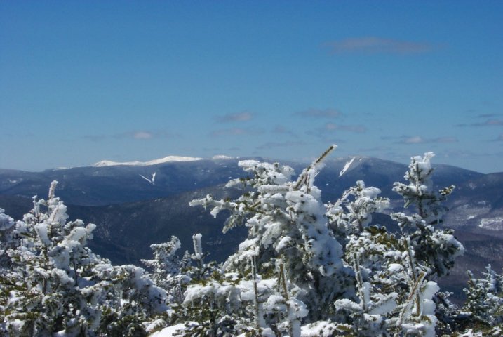
The ridge between these two peaks has some beautiful dips, turns, and tree tunnels to compliment the extraordinary 360° views. Dipping down, twisting, ascending again makes this walk feel a bit like a roller coaster, which I thought was kind of fun. We were making good time so I stopped to take a shot of a neat looking open area of sparkling snow and scrub trees. The openness of the ridge allowed for plenty of wind-protected depressions as well as wind-blown, icy patches. In one of the protected areas, we met a nice woman nursing some blisters with mole skin. We chatted for a minute or two and she was kind enough to take a picture of the group with Eisenhower in background.

At 4.3 miles the Mt. Eisenhower Loop diverges from the Crawford Path and the trail finally gets a little steeper. At this point we were feeling a little fatigue and stopped a couple times for recovery, but the wind and the excitement of Eisenhower kept us moving. During the warmer months, I can imagine the wind we were experiencing would be described as a wonderfully robust breeze, and I may have to do this hike again to find out!

Our final press to the summit was invigorating and I was starting to feel that familiar burning in my legs. The trail turns back on itself along the side of the peak and makes a final northerly turn 100 yards before the summit. We walked the last few feet and arrived to one of the best views in all the White Mountains. Before long, we were all standing on the summit cairn taking our victory photos. Shortly after that, it was time for a snack and some rest. Jen brought some awesome trail mix (peanuts, yogurt covered raisins, chocolate chips, and dried cranberries w/ a hint of orange) which she was kind enough to share. We all ate a bit, drank a bit and enjoyed the view. After identifying as many of the peaks as we could, it was time to head back.
Although we had decided not to continue on to the Edmands Path due to our inability to spot a car, a short discussion changed our minds. We decided to walk the Mt. Clinton Rd back to the Crawford parking area so we didn't have to backtrack. So we started our trek down the remainder of the Mt. Eisenhower Loop to join Edmands Path.

The walk off the summit is rocky and steep in places, and before long several of us had slipped and hit the deck. Since none of the falls were at all serious, we just kept a cautious pace. At .3 mile from the summit, we turned left onto the Edmands Path, which circles around the peak as it descends. There continue to be excellent views the whole time and some quality photos can be taken at any point.
The further we got from the summit, the more obscured the view became until about .4 down the Edmands Path, where views essentially vanished. We fought some very loose snow with very shaky footing most of the way down from the summit, but we all managed ok and descended into the thicker forest. Edmands Path is definitely steeper than the Crawford Path, and I quickly noted how glad I was that we were going down this route rather than climbing it. Our pace was good, not too fast or slow, and within an hour of leaving the summit the trail was flattening out. As we dropped in elevation we shed some more layers and ambled down to the parking lot off the Mt. Clinton Rd. We were almost relieved until we remembered that we still had the long walk back to the parking lot, 2.3 miles away.
Without the walk along the Mt. Clinton Rd. this was 8.1 miles with 3100 feet of elevation gain. It sounds formidable, but anyone in halfway decent shape can make this trip. When all was done, we made the hike in about 7.5 hours including rest time at both summits and a very relaxed pace. The views on this hike rival any in New England, and perhaps in the US! And with two 4,000 footers off the list, this hike is a must-do for anyone!

Chris Oberg & Robert Havasy
Hike-NH.com