 |
Mt. Washington Temp.
Click pic for forecast.
| ...More Topics... |
 Books Books |
| Bulletin Board |
| Clubs & Huts - AMC Huts |
| Feedback |
| 4,000 footers |
| Hiking Glossary |
| Mail List |
| Privacy Policy |
| Store |
| Weather |
| Search |
|
|


![]()
![]()


A Spectacular Hike Up the North Slide is Well Worth the Effort
Click HERE for a summary of this hike with maps!
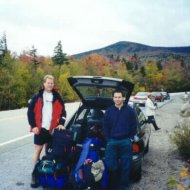
Things at work for both Rob and me were getting to be a little too much to handle, so we decided that a nice, three day weekend in the New England foliage was just what we needed. As if we needed convincing,
 our collective subconscious decided to make things painfully evident: this trip to the Tripyramids was riddled with forgetfulness.
We started out from my place and got 15 miles from home before I realized that I had forgotten my rain jacket, which also was to serve double duty as another layer for warmth. So, we turned around and wasted a half hour getting it. Finally on our way, we joined hundreds of other cars driving in New Hampshire’s famous fall foliage. Choosing a hike off the Kancamagus Highway may not have been the best idea in the world, but we didn’t really care.
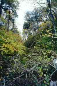
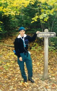
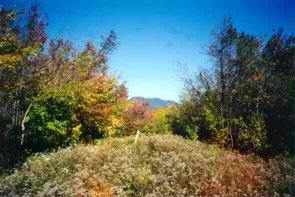
 Our hike began at the Livermore Trail just opposite the Lily Pond about 12 miles from Route 16. This trail head appears to have moved over the years as we were soon to find out. The beginning of this hike is beautiful, especially in autumn. It follows an old logging road used prior to the 1940s for dragging valuable timber out of New Hampshire’s rich forests. Not more than ½ mile in, the trail takes a peculiar left turn at the post seen here. This is NOT an obvious turn, as the post has no sign, only a painted yellow
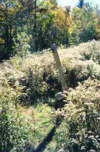 arrow that looks suspiciously like a teenager playing a joke on you. It isn’t however, and we continued off the logging road, into the woods. The trail is fairly well kept, with the usual assortment of roots and rocks to keep you on your toes (or on your butt).
Just to show me up (I’m sure) after hiking about 10 minutes, Rob stopped and realized that he’d forgotten his cough medicine, decongestant, nasal spray, Tylenol, pace maker, artificial limb, and iron lung. So he abruptly dropped his pack, swore a lot, and ran back to the car. That was twice.
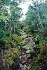
 So on we went. At this time of year, things can get cold very quickly when the sun goes away, so I found myself adding layers before we even got a mile in. After about 1.5 miles of smooth sailing, the Livermore Trail begins to climb into the . . . you guessed it . . . Livermore Pass (2863 ft.). As we got closer to the pass, the trail gained steepness and started to follow a dry stream bed.
Before long, we reached the top of the pass and began noticing fresh moose prints in the mud. Rob informed me that mooses like marshy areas like this, and that this was not surprising (he’s so smart!). As the astute may have noticed, I said we noticed these prints in the mud. And I do mean mud. The trail was VERY wet from here on, as we had seen a fair amount of rain the previous two days. To make things even more interesting, the section of the trail from the Livermore Pass to the junction of the Scaur Ridge Trail is very haphazard and sometimes difficult to follow. When avoiding 12 inch deep mud (Rob can attest to the depth, just check his pants!), we often found ourselves searching for a blaze or other semblance of trail identification. But we managed to get through without too much difficulty; and before long we reached the trail junction and another, more well-kept logging road. We had planned to begin looking for a campsite near this junction because the topology flattened out nicely, and there was a good chance there was water near by (although not if you read the White Mountain Guide).
Within 15 minutes we spied a nice clearing off the side of the trail, which we noticed because a large kettle stood, rusting at what appeared to be an old logging camp. There was plenty of room and a fire ring was waiting for us, so we dropped packs and went looking for some water. As fortune would have it, there was a full stream 100 feet away with an old apple tree that stood sentry not five feet from the stream’s edge. Perfection like this is seen maybe twice in a lifetime, so we called it good and returned to set up camp.
Our plan was to stay for two nights at this location, because we looked at the topo for the trail we were about to hike, and it looked nasty. So, feeling like it would be more work than we’d like to carry full packs up the Tripyramids, we planned to use only fanny packs and Platypuses for our climb. We ate, prepared for the next day’s hike and sacked out.
Saturday morning looked fair, some clouds remained but the sun poked through whenever possible and gave some warmth to the day. Rob had gotten up early to check the trail out a bit, while I snored blissfully away in the tent. We got going at about 10:00 AM after a good breakfast and some serious organizing. We hadn’t seen a single person on the trail up until that point, so we weren’t too worried about leaving our stuff in the tent unprotected. We continued on the trail for about 200 yards before it widened and became a two-track Forestry Service road and began a descent. About a mile from our camp, we reached the junction of the Scaur Ridge Trail, the beginning of the climb. It was here that we
 saw our first human, a guy who’d mountain biked from Waterville Valley and was about to make the same silly ascent up the North Slide.
If you’ve ever seen the topo for this climb, you’ll understand why we planned to carry as little as possible. The trail gains 2,000 feet in elevation in less than a half mile. Also on the map, you’ll see that most of this follows a rock slide that happened some time in the
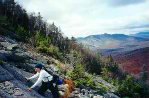 1840s, making the elevation gain dangerous when wet. We therefore figured that we’d have to be STUPID to carry full packs up that trail. And if you, the reader, has carried a full pack up that slide, forgive me, but you’re stupid.
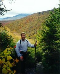
After a solid hour and a half of climbing, we reached the top of the slide and followed the trail into the wooded summit. The temperature at this point was pretty well freezing, as evidenced by the icicles in the moss. Another 100 yards and we were at the summit of yet another 4,000 footer.
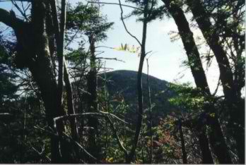
The summit of North Tripyramid is mostly occluded, but a single nice view is available. If you do some searching, you
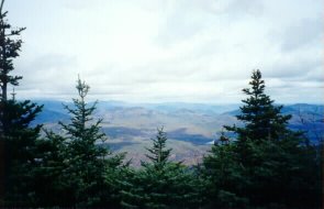 can find some areas where views are available, but if you’re looking for a wide open summit, you’re not going to get it.
After appreciating the slide and the summit view, we grabbed some dirt and ate lunch. Within 20 minutes the summit had at least 15 people on it, ruining the solitude we’d hoped for, so we packed up and moved on to Middle Tripyramid, a mere .95 miles away.
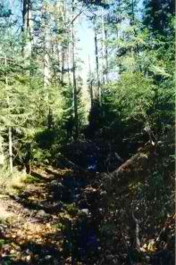
The hike between the two mountains is relatively easy, with no real steep or difficult sections. Our biggest hurdle on this part of the trip was to resist the temptation to throttle the original Tuberculosis Boy
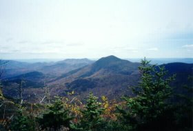 following us at close range. Within 35 minutes we reached the top of Middle Tripyramid, where nice views were available to the East and West. Again, the summit got crowded quickly, so we evaluated our options. It was getting dark
more quickly these days, and the hour was progressing, so we made the executive decision to bypass South Tripyramid and head back to our camp. We backtracked across the same trail to the north peak, then diverted to the Something Brook
Trail to avoid having to walk down the North Slide. By 4:30 PM we were back at camp making dinner and preparing to get some serious shut-eye.
following us at close range. Within 35 minutes we reached the top of Middle Tripyramid, where nice views were available to the East and West. Again, the summit got crowded quickly, so we evaluated our options. It was getting dark
more quickly these days, and the hour was progressing, so we made the executive decision to bypass South Tripyramid and head back to our camp. We backtracked across the same trail to the north peak, then diverted to the Something Brook
Trail to avoid having to walk down the North Slide. By 4:30 PM we were back at camp making dinner and preparing to get some serious shut-eye.
Sunday was a great day. The clouds had mostly dissipated, and the temp was up. We again backtracked through the
 Livermore Pass and had an uneventful walk back to my car. Rob was slightly delirious at this point, confusing the pass with the base of North Tripyramid, but he got over it and we walked out just after 1:00 PM. We then moved on to our traditional after-hike eatery, the Yankee Smokehouse. If you ever have the chance, go there and eat. It’s incredible, especially after a long hike.
That's about it. This is a great hike to take a couple of days on, because the scenery is fasntastic,there are several good places to camp, and the trail is only at a slight grade until you reach Tripyramid. But if you want to tackle the north slide, you'd better be in good shape . . . .
Chris Oberg & Robert Havasy
Hike-NH.com