 |
Mt. Washington Temp.
Click pic for forecast.
| ...More Topics... |
 Books Books |
| Bulletin Board |
| Clubs & Huts - AMC Huts |
| Feedback |
| 4,000 footers |
| Hiking Glossary |
| Mail List |
| Privacy Policy |
| Store |
| Weather |
| Search |
|
|


![]()
![]()


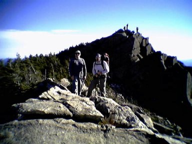
Mt. Flume and Mt. Liberty
by Bill Newman
Hike Length: Dayhike
Trails: Mt. Flume and Mt. Liberty via The Flume Slide Trail for ascent and Liberty Springs Trail for descent.
Date: October 23, 2004
Our previous attempt to climb Flume and Liberty a few weeks ago was scuttled due to bad weather and we ended up climbing Cannon. This time weather was in our favor and we decided to make our last hike of the year a memorable one by using the infamous Flume Slide Trail. While there are hundreds of trails in the Whites very few have reputations that make them stand out from the rest. The Flume Slide is one of them due to the vertical ascent along a rock face of approximately 1600 feet in .8 of a mile.
We parked at The Basin just off 93 in Franconia Notch at about 9:30 AM. This was a beautiful Saturday morning but there was only 1 other car in the lot. The parking is free and there is enough room for plenty of cars before you’d have to park on the medians. The trailhead is off the paved bicycle path and you need to hike about ˝ mile before you reach it. We think there is an easier way to the trailhead by parking near The Flume Gorge but didn’t check it out. This could be why there were no cars in the lot we parked in! The trail actually starts out as The Liberty Springs Trail and at the .5 mile mark splits off between the Flume Slide and Liberty Springs trails.
The trail is slightly sloped from here until you hit the headwall but you follow along the base of Mt. Liberty and catch an occasional glimpse of both peaks. There are a couple of stream crossings but the level was low and they were no problem. This is probably not the case during the spring. It’s a very easy trail to follow and is well marked until the serious ascent begins. Even with a lot of leaves on the ground we had no problems until we hit The Slide.
The .8 – 1-mile climb up the slide is interesting to say the least and I would caution anyone attempting this during bad weather. The slide has quite a bit of exposed and sheer rock face and water along these areas makes it even more difficult for traction. This section of the trail is not well marked and there are quite a few sections where people have blazed their own way along the sides of the trail instead of following along the main route making it trickier to decipher the real path. But the real challenge with this trail is that there is a lot of hand-over-hand and root grabbing work in order to get up it. Even with some nice Vibram soled boots, I was not comfortable with the way I couldn’t get good foot holds at certain areas and found myself sliding backwards. There is very little upright hiking along this section as it’s almost all “climbing”. Once you get to the top of the slide the Osseo trail intersects here to become the Franconia Ridge Trail and it’s an easy .1 of a mile to the summit of Mt. Flume. It’s not a large summit but has some great cliff like views for picture taking. It was about 1:30 so the ascent time was 3 ˝ hours. We had lunch and then went on to Mt. Liberty.
From the top of Mt. Flume it looks to be a difficult 1.2 miles but after going up the slide it was an easy hike down and then up to Liberty and the summit comes up fairly quickly. I liked the summit of Liberty a little more as there are plenty of great views to The Bonds and Washington to the East, Cannon and Kinsman’s to the west, and Lincoln and Garfield to the north. Plus it has a bigger summit so when the 20 or so people from a Canadian hiking group came through, we still had plenty of room in the jagged edges to eat lunch peacefully. We did come across some snow and ice but nothing that interfered with the hike, and it was mostly on the North Face of each mountain.
We were making this a 2-mountain loop so we headed back down using the Liberty Springs trail. You can continue along the Franconia Ridge trail to Little Haystack, Lincoln, and Lafayette for one huge loop (the parking lots for each trailhead are about a 1-2 miles apart, I think). There isn’t too much difficulty to this trail and I HIGHLY recommend using this for descent instead of The Flume Slide. We did pass one of the largest AMC tent sites in the Whites at Liberty Springs and quite a few of the platforms were taken. It looks like a great “high altitude” place to camp in order to hit several summits, as it’s only .3 of a mile from the ridge. There is usually a caretaker to collect the site fee but I think the AMC doesn’t maintain this site after Columbus Day. Click on the link on this page for more information about the tent sites and the AMC. The total hiking time was about 8 hours for a 7.4 mile hike but this includes time at each summit, lunch, and the fact that we’re slow old men.
I have read the description of the Flume Slide and see that they rate is as Difficult, and I can’t agree more. This is not a good trail for descent and I would not consider climbing it during any poor weather conditions. I can’t stress these points enough. Just another great hike and 2 more of the 48 have been checked off.
Special Equipment: Good balance and a great grip!
Chris Oberg & Robert Havasy
Hike-NH.com