 |
Mt. Washington Temp.
Click pic for forecast.
| ...More Topics... |
 Books Books |
| Bulletin Board |
| Clubs & Huts - AMC Huts |
| Feedback |
| 4,000 footers |
| Hiking Glossary |
| Mail List |
| Privacy Policy |
| Store |
| Weather |
| Search |
|
|


![]()
![]()


Mt. Cabot
by Steve McGilvary
Hike Length:
Trails: Mt Cabot Trail to Bunnell Rock
Date: 9/1/2002
This Sunday was sort of a repeat of last Sunday. I woke up in Manchester to cool & cloudy weather, so I figured I’d hit a wooded peak. Distant Mt. Waumbek was the target last weekend. It only seemed appropriate to finish off Mt Cabot, the highest peak in the North Country, today. And just like last weekend, the skies up north turned out to be clear and the sun hung around most of the afternoon.
My big dilemma was where to begin this hike. Like most peak baggers, I’ve read numerous web articles about some dispute between a landowner and the WMNF that has shut down the Heath’s Gate trailhead. With this traditional route to Mt Cabot blocked, the next best approach seemed to be from Mill Brook Road in Stark via the Unknown Pond and Kilkenny Ridge Trails. But the night before my hike I read 2 very recent trip reports on the “Views From The Top” website which mentioned easy sailing right from Heath's Gate. One trip reporter named “Sikes” questioned a nearby property owner and was told there’d be no problem using the trail. I decided I’d at least look in to check whether this option was open to me. And after following the precise directions spelled out in the AMC Guide, I was thrilled to see that Heath’s Gate was active with hikers and all was peaceful at the end of Arthur White Rd.
The little parking lot near the end of Arthur White Rd was already jammed with 6 cars when I arrived at 10:30, so I parked on the side of the road. Heath’s Gate, the trailhead for the Mt Cabot Trail, is literally a rusty gate just 50 yards up from the parking lot at the end of the road. There’s no sign, but you’ll know you’re at the right spot if you see a woodworking shop to the left of the gate. I followed a well-trodden path around the gate and started down a logging road.
I strolled along on an even grade for about half a mile until I was confronted by another 3 gates: one to my left, one to my right, and one directly in front of me. I made the right choice and slipped around the gate right in front of me. Now the trail begins a slight ascent and also gets a bit shaggy with lots of overgrown grass. The logging road continues on for another half mile where it finally enters the woods and narrows to a footpath. I encountered a few spongy sections here, but well placed stones kept me out of the muck. The lower part of the Mt Cabot Trail is very easy and acts as a good warm up for the steeper sections to come.
It didn’t seem as though I was in the woods very long before I came to the Bunnell Brook crossing. And at last, I saw my first posted trail sign of the day! Even though I was sure I was on the right track, it made me feel a whole lot better to spot that plaque that read: “Mt Cabot Trail.” The brook itself was no more than a trickle, and I hustled across without missing a beat.
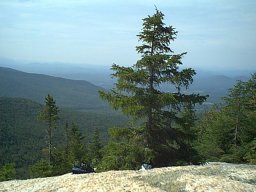
The upper sections of the trail are rock strewn and somewhat steep. If I had reported on this hike earlier in the season, I would probably have described this section as being “challenging”. But my legs and feet are trail hardened now, and I never felt the need to stop and rest. Just before getting to the top, I took a short side path to a great ledge called Bunnell Rock. It offers some very pretty views of farmland below. This must be an unbeatable perch to just sit and soak in the foliage when it’s at its peak. I took some pics and chugged some water.
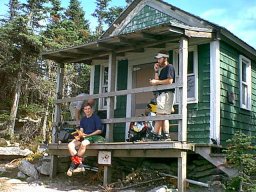
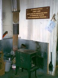
Not far up the trail from Bunnell Rock, I arrived at the Mt Cabot cabin. From what I’ve read, this shelter was originally used by the fire warden back in the days when a fire tower stood near the summit. Now the cabin is maintained by the Jefferson Boy Scouts and is available to all hikers on a first come first served basis. It sleeps up to 8 on padded bunks and is equipped with many essentials: a sturdy wood stove, propane stove, tea kettle, coffee pot, cooking utensils, candles, shovel, saw, ax, broom, map of the area, playing cards, bible, etc. There’s even a large plastic barrel outside to collect rainwater.
The views from the cabin’s porch are unobstructed (some boy scouts have obviously been busy with the saw & ax) and very nice. The only thing marring this lovely campsite is the noxious odor that periodically wafts over from the outhouse just 25 yards away. Yuck! But I guess you have to take the good with the bad. I still wouldn’t mind planning an overnight here sometime.
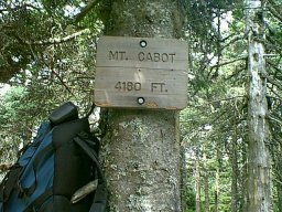
A short hike up from the cabin brought me to the open site of the old fire tower and more views of the surrounding mountains. From here I hiked an easy 3 or 4 tenths of a mile to the true summit of Mt Cabot. There’s no cairn, but there is a nice summit sign nailed to a tree. I took several summit pics and then sat down in the clearing to eat my peach (I forgot to buy a powerbar for this trip) and watch other hikers pass through. I stuck around for about 30 minutes before packing up and heading back down the mountain.
I really enjoyed this trip; everything seemed to go my way. I don’t know if it is official yet or not, but I considered it a good omen to find Heath’s Gate accessible. This, along with Bunnell Rock & the Mt Cabot cabin, all combined to make the hike very interesting and different. I almost regret that I didn’t save this one to finish up my list.
At any rate, I feel confident that I’ll bag my 48th peak with plenty of fair weather hiking days left in the season.
Chris Oberg & Robert Havasy
Hike-NH.com