 |
Mt. Washington Temp.
Click pic for forecast.
| ...More Topics... |
 Books Books |
| Bulletin Board |
| Clubs & Huts - AMC Huts |
| Feedback |
| 4,000 footers |
| Hiking Glossary |
| Mail List |
| Privacy Policy |
| Store |
| Weather |
| Search |
|
|


![]()
![]()


Two 4,000 footers in just under 6 hours
The weather report said that it was going to be party sunny, but unfortunately the old axiom takes
 precedence: Never trust the weather report.
Rob and I started out early on Sunday morning because we had to get back by 7:00 PM to play hockey. A noble pursuit, I know. So at 7:45 we left my house and made the hour and a half drive up to the Kancamagus Highway, where we were to start. By the time we got to the hairpin turn (for those of you who know the Kanc.), traffic was already starting to gather. By 10:30 we had parked in the small, but sparse parking area (something to remember if you’re planing this hike) and started out with our day packs.
The beginning of the hike to Osceola follows the Greeley Ponds Trail, an easy mile long "highway" that just about anyone could hike, as long as they aren’t 300 lbs. overweight. Some areas of the Greeley
 Ponds Trail are rather wet, but the AMC has provided numerous log bridges to traverse these wet areas.
After an hour of steady but not strenuous hiking, we reached the junction of the Mt. Osceola Trail, which has been moved according to the AMC. At this point we decided that a quick trip to Greeley Ponds was unwise, as we were on a time budget. So 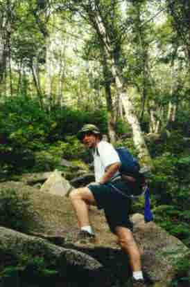 we turned right onto the Osceola Trail, which immediately began climbing. As can be seen from the Topographical, the trail begins to climb gradually, and gets steep. This, we found, is an understatement. The further along the trail we climbed, the steeper it got. About halfway up the East Peak, we stopped to take a gradient and discovered that we were following a 56 degree slope. NOT what I’d call user friendly. However, there were some fantastic views periodically. Mountains such as the Tripyramids (4180, 4140, 4100), Hitchcock (3600), Hancock (4420), South Hancock (4319) and Tecumseh (4003) are all within view if you look carefully enough.
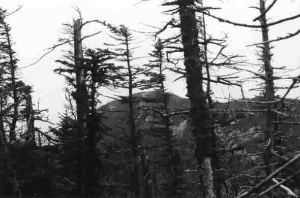
After whining and crying for what seemed like hours, we made it to the summit of East Peak (4156). From the time we left the parking lot to the time we bagged the peak was really only 2 ½ hours. Not too bad for a couple o’ couch potatoes. Some views are available from the summit, but overall it is wooded and difficult to see from. A little investigating provided us with some reward, as we caught a glimpse of some of the surrounding peaks. From what we could gather, the photo below shows West Peak (4114). Osceola was only viewable through the trees.

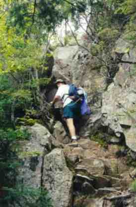
After a half hour and some Clif bars (Peanut Crunch, not too bad) we moved on to Mt. Osceola. The trail descends noticeably for about 500 feet before it starts a SERIOUS climb to Osceola. What we soon found out was that the 56 degree incline we determined climbing the East Peak was nothing in comparison to the gradient of Osceola. Below and right we see Rob incorporating some rock climbing skills to get past one section of trail.
But before long, the trail flattens a little and we could pick up a little speed. We were trying to calculate how much time we’d need to get back to Dover to play hockey, and our hopes of taking the scenic diversion to the Greeley Ponds were quickly disintegrating. So we pressed on until Rob stopped dead in his tracks in front of me and quickly hushed me. Sitting on the trail ahead of us were two Rough Grouse, pecking for food. Moving as slowly and deliberately as possible, I pulled my camera from my pack and shot a few quick photos.
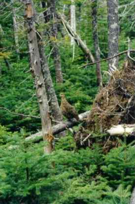 The two birds seemed quite at home with us, and made no real attempt to flee. In fact, one even seemed to be posing for me as I snapped his picture. I muttered something about it being no surprise these things get shot all the time and we moved on.
By 1:45 (almost 4 hours after we began) we reached the peak of Mt. Osceola. The last little climb to the summit is a little tough, as can be seen below . . . just kidding. The summit was a little crowded, but we searched a little and found a secluded place to eat lunch. Before too long, we were the only
 ones on the summit and I managed to get a couple shots of the quickly graying panorama. Click for shots to the South, East, and North/North East of the summit.
From this shot, Waterville Valley the town and ski area can both be seen (although not clearly).
 By 2:30 we decided it was time to get back, there was hockey to be played! So we began to retrace our steps back to the East Peak when a slight rain began to fall. Not too concerned, we pressed on. As a safety measure, I placed my camera in a slightly more waterproof location and we clamored back down the cliffs of Mt. Osceola. With an hour that slight rain had turned into a steady, drenching rain that soaked us, the trail, and anything else that was dumb enough to be on the mountain. The rain made travel slippery and slow, and as we passed several (stupid) people hiking in cotton, we could only shake our heads as they shivered and waded through their own personal misery. By 5:00 PM we were back at the parking area, soaked to the bone, but relatively happy nonetheless.
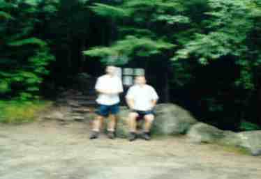 I wanted an "after" picture, so we asked one of those (stupid) people to take a picture of Rob and me, and below is the result. Need I say more?
All in all, a good hike. I'd say if you're not in good shape, leave a full day to hike. If you add an overnight pack, add at least a couple hours to your hike.
Grab a day pack and get movin'. It's worth it.
Chris Oberg & Robert Havasy
Hike-NH.com