 |
Mt. Washington Temp.
Click pic for forecast.
| ...More Topics... |
 Books Books |
| Bulletin Board |
| Clubs & Huts - AMC Huts |
| Feedback |
| 4,000 footers |
| Hiking Glossary |
| Mail List |
| Privacy Policy |
| Store |
| Weather |
| Search |
|
|


![]()
![]()


Mt. Jefferson via the Caps Ridge Trail
By ChrisThe summer was slipping by far too quickly, as usual, and a friend that I play hockey and volleyball with tempted me by asking if I was interested in going hiking. Being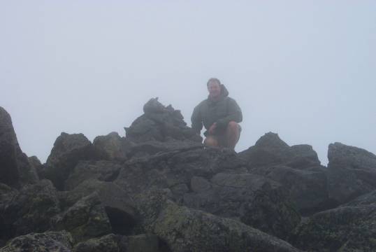 unemployed and all, I thought, "What the hell! It's better than inching closer to hara-kiri with each and every day!" But then the question was, where to go? It turned out the answer was Mt. Jefferson! Wow, this whole time it was there and I never walked up. Huh. Weird.
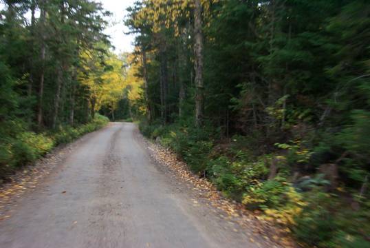
We got up way too early on a questionable Friday morning and made our way up Route 16 to the middle of NH. I feel the need to mention the scenery of drive to the trail, because it is one of the nicest trips you can take in New Hampshire. We traveled up NH 16 to NH 302 through
 Bartlett and then Crawford Notch State Park. The scenery is enough to make a 90 year old man who's allergic to bran mess his Depends, it's that gorgeous. And of particular note is the Mt. Washington Hotel, which is situated just off 302 in Bretton Woods. It truly is a spectacular hotel, and if you've never stopped in to take a look, you should really do so. Their website has some great photos in their Photo Album section.
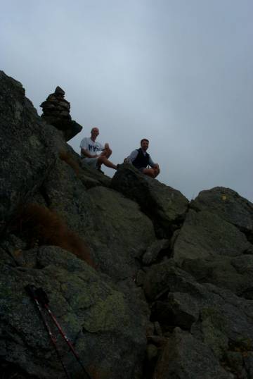
To get to the trailhead, you need to take Base Rd. from Bretton Woods to the Jefferson Notch Road, which happens to be the highest State maintained road in NH. The road is pretty cool, but isn't for the weak of bladder. We got to the trail at about 10:30 and snapped our "before" picture before heading out.
My partners in crime this hike were Paul Martin and Tom Bergeron, two hiking junkies that are trying to knock off the top 5,000 footers in NH so they can feel like real men (just kidding guys!). The day started out pretty nice, with Tom making fun of Paul for wearing cotton shorts and t-shirt, which was cool because I didn't have to! The weather was questionable; clouds and intermittent rain, which gave us pause, but we were prepared so we headed out anyway.
As the White Mountain Guide professes, the beginning of the trail is a little wet, with log bridges providing some relief from the H2O, but not much. Tom misstepped just a little and found out how deep the mud beneath was (about 6"). After about 100 yards the grade began, slowly at first. We were well aware that the Caps Ridge Trail is about 2.5 miles long with about 2,700 foot elevation gain (for the math impaired, that's about 49 feet of elevation gain for every 100 feet walked, or approximately a 42 degree incline). But don't be deceived, the grade increases and eventually gets to the point where you need to do some scrambling, but more on that later.
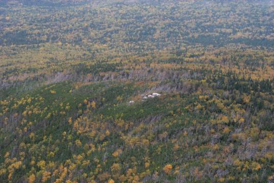
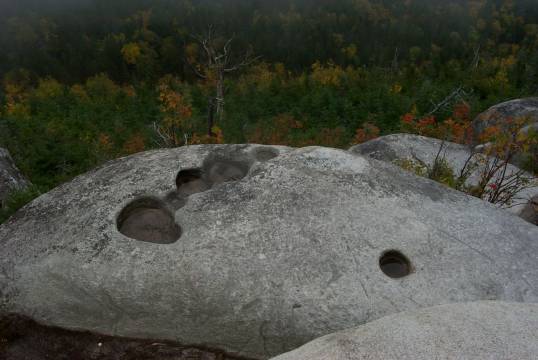
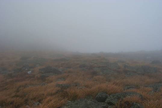
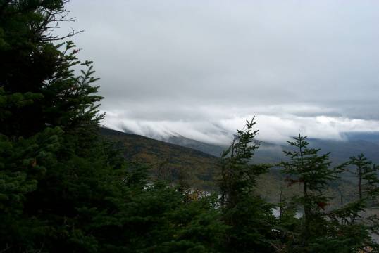
After 15 minutes of walking through wooded trail, our first view presented itself on a southerly granite outcropping just shy of the junction of the Link Trail. The book says this is at one mile, but I think it's just shy of that. The potholes there are an interesting sight, and with a little imagination, one even looks like a prehistoric foot print. If you look up at the trail from here, you can see the first of the caps for which the trail is named. Looking south, you can see some amazing ridges, which were serving as pathways for clouds when we were there. The view here should be great, but on this day we were a little socked in.
As we moved on, we were greeted with the smell and sounds of the Cog Railway that ascends Mt. Washington. It was a nice surprise, and got me moving a little quicker, as I was hoping to catch a glimpse of the railway. But that was not to be, since a ridge from Mt. Clay blocks any hope of seeing the train. You can, however, see the plume of smoke from the engine as it chugs up Washington.
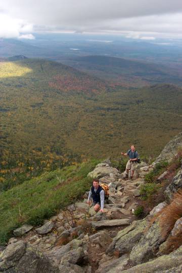
Not long after leaving the outcropping, the trail breaks the tree line and turns mostly to granite rock-hopping. It's not too bad, but makes a point about having sturdy boots. At about 1˝ miles the trail gets very steep and you arrive at the first cap. From here the views are spectacular in a southerly and westerly direction. Look carefully and you can see the granite outcropping with the pot holes earlier on the trail. On a nice day 50-100 miles should be visible, especially to the west.
We took a few snapshots and moved on to the next cap. The trail is broken and rocky, making footing tough, but only if you're a real klutz and don't look where you're going. Keep your eyes open, and you should be able to follow the blazes and make your way slowly towards the summit.
Much like the fist cap, there are some great views from the second cap. We took the opportunity to stop and get a little nourishment (translation: I was sucking wind, so Paul and Tom were nice enough to stop and eat something while I tried to figure out how my lungs could leap out of my chest and then get back in so quickly). It was getting quite windy at this point and the clouds were REALLY threatening, but being the crazy mountaineers we are, we kept our rain gear handy and kept moving.
About ˝ mile past the second cap, the first bit of rain began to hit us. Tom and I donned our GoreTex rain gear, bundled up and prepared for the rest of the hike. As if he knew that he was responsible for comic relief, Paul put on his Blaze Orange Nylon poncho. Yes, you read that correctly. He was like a shining beacon of dorkiness on the side of a huge mountain! The only thing that surpassed the site of this glowing blob was when a gust of wind blew the poncho up over his head Marilyn Monroe-style. I nearly fell off the mountain laughing!
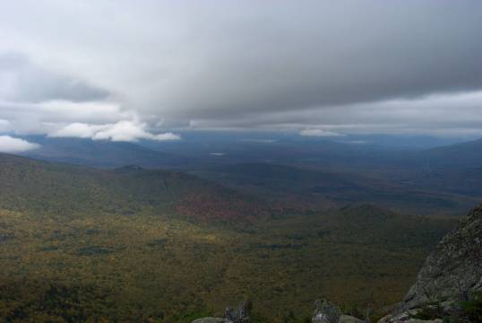
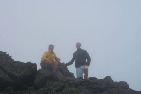
Anyway, back to the trip. About ˝ mile further along the trail, the Gulfside Trail enters. This leads to Mt. Clay to the southeast, and also provides a diversion to the Monticello Lawn, which we'll cover a little later. We chose to continue up towards the summit, occasionally getting rained on. The rest of the way up to the summit is uneventful. Some steep climbing and you're there. The summit is small (just a little rock sticking up) but offers some stunning views in all directions (or so I'm told). We couldn't see more than 20 feet, since we were in the clouds. We had gotten to the summit in about 2Ľ hours, thanks to my frequent rest and view stops.
A brief respite and we were eager to move on. The weather was not cooperating, so the summit was probably the worst place to be. Paul had seen something about a plateau called Monticello Lawn that was supposed to be spectacular, so we headed out on the Castle Trail towards the Lawn. Within 15 minutes we found the neighbor's lawn, much smaller but still beautiful. A little further and there it was, what must be almost two acres of mountain grass and granite. This is definitely a worthy stop if you have the time.
We made a quick stop to admire this amazing plateau and moved on. The rain was a little steadier and we were quickly losing patience with being cold and wet. As I had gotten used to the pace Tom and Paul set, we began the trot down the mountain. The run down took only about an hour and 20 minutes. The parking lot was there waiting for us, and no one had broken into Paul's car! Thank goodness, since he had 27 gold bars hidden in the trunk.
Postscript: I am embarrassed to say that we didn't stop at the Yankee Smokehouse on this trip. That makes TWO trips in a row. Please don't take this as a sign that I don't like the Yankee Smokehouse anymore, only that I have obviously lost my mind. Next trip I'm going for sure!!
Chris Oberg & Robert Havasy
Hike-NH.com