 |
Mt. Washington Temp.
Click pic for forecast.
| ...More Topics... |
 Books Books |
| Bulletin Board |
| Clubs & Huts - AMC Huts |
| Feedback |
| 4,000 footers |
| Hiking Glossary |
| Mail List |
| Privacy Policy |
| Store |
| Weather |
| Search |
|
|


![]()
![]()


A great first hike of the Year . . . .
Click HERE for a summary of this hike with maps.
 As sad as it is, our first hike of the 1999 season was completed at the end of June on Mts. Jackson and Webster. Although we planned somewhat at the last minute, we were excited to get out on the trail.
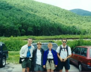
We thought planning a hike on Motorcycle weekend was going to be a suicidal undertaking, figuring the 60 mile trek back home would take us roughly 4-5 hours with all the traffic, yet Rob, Dave Marquis, Kristie Wentworth, Pamela, and I headed up Rt. 16 to Rt. 302 anyway, eager to get the first hike of the season under our belts. We were not going to be disappointed . . . .
 The ride to the Crawford Notch area was beautiful, with sprawling growth surrounding the roadsides, and foliage in full bloom. Route 302 from Conway is a fantastic ride, one that could be driven solely for its scenic qualities, but we were more interested in getting to the trail head. Just 100 feet past the Elephant Head (a granite outcropping that looks like an elephant's head [sort of]) we parked in a shallow parking lot next to an old railroad bed. A short distance up the road we found a rail station (a great place to make that last "pit stop" before getting under way) and the Crawford Notch Hostel, a haven for AT hikers that is considered some of the nicest accommodations on the entire trail. Once satisfied, we hopped on the trail and got moving. The trail enters the woods on the east side of the highway. It is marked with blue blazes that change slightly in hue over the length of the trail, but is otherwise well marked, clear, and easy to follow.
 Almost immediately, the Jackson-Webster trail started a moderate but consistent ascent with only one flat area that lasts for about ¼ to ½ mile. It proceeds through a dense pine forest all the way to the summit. The cover on either side of the trail is very dense, and with the exception of a few clearly defined areas, finding a campsite would require a decent amount of bushwhacking. That's not to say that there are no decent spots, just that you will have to put in some legwork to find them. Footing was fairly good, although we could see that this wouldn't last. They don't call NH "The Granite State" for nothing. About .1 miles from the start there is a small side path that leads out to the top of the "Elephant's Head" rock. On the way up, we didn't want to waste the time checking this out, figuring we'd hit it on the way back. On the way back, we were way too tired to stop, so we can't really tell you whether or not this little .2 mile side trip is worth the effort. If anyone goes there, please let us know. Continuing on, the trail got slightly steeper, and before long (at .6 mile) we came to the Bugle Cliff, the first of many fantastic views.
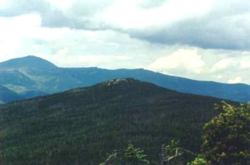
 We continued on the Jackson-Webster trail, gaining steady elevation. Before too long we passed several streams, or "babbling brooks" as Pamela likes to call them. After 1.3 miles, we reached the junction that split the trail between Jackson and Webster. We chose the Jackson Summit route and continued on our way. At about 2 miles, the trail begins to get steeper, making fast walking a chore. But the effort pays off, because only .5 mile further up, you reach the summit of Mt. Jackson (4052 ft.). The views from the summit were spectacular in all directions.
The summit of Webster (3910 ft) can also be seen easily from Jackson, but what lies in store for you there can only be witnessed.
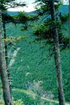
We took advantage of the wide-open summit of Mt. Jackson by resting and eating. It had only taken 2 to 2 ½ hours to get there, so we took our time and enjoyed the scenery. When we'd rested enough, we made the move to the Webster Cliff Trail and started the hike to Mt. Webster. The trail is only a mile long, and offers very little elevation change. To get across the ridge, only 400 feet are lost and 300 are gained back over a long, comfortable walk. So we used this trek to gain a little energy, but nothing gave us more energy than the views when we reached the summit of Webster. Cliffs surround this summit in several spots, making that last step a doozey. The rock formations contain small chunks of quartz that make the geology look very cool. Mt. Willey, Mt. Field, and Mt. Avalon are in full view across the valley, which falls about 1500 vertical feet from the summit of Webster (the summit is partially occluded). Also in the immediate area are fine views of Mt. Washington, Mt. Monroe, and Mt. Eisenhower.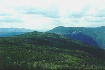
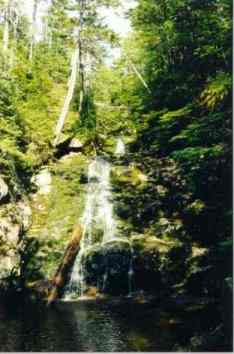
We left the top of Webster only when the hour had started to concern us; this was Motorcycle Weekend, after all. So we began our descent down rough terrain through thick woods. Getting off the summit was tiring, as the climb is steep and rocky. But before we could get too grumpy, we happened upon the Silver Cascade falls, a 30 foot waterfall that concludes in a shallow pool of clear water. I took the opportunity to refill my Platypus while Rob, Pamela, Kristie, and Dave sat on the rocks and admired the scenery. The picture directly above is one gorgeous waterfall, well worth the hike up from the road, even if that's all you're looking for.
Once again, timing was concerning us so we made the strenuous climb up the bank of the falls to the Jackson-Webster trail junction and continued our descent to the Crawford Notch area. The trip back was quiet, mostly because this was a tough hike. 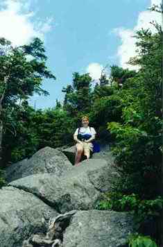
At 6.5 mile round trip, this doesn't seem like a vigorous climb, but this hike can really take a lot out of you. The steep, steady grade, the abundance of large rocks, and the varying terrain make this a tiring climb. The entire loop crosses 3 or 4 streams; It is worth noting that none of the stream crossings posed any trouble, and no one's boots got even splashed, however, the Silver Cascades crossing on the return trip takes place in a deep gorge, and might be a problem with high water. Although the ground was damp for our trip, we have been experiencing one of the driest Junes on record this year, and so the water was likely much lower than normal. So, we caution – don't underestimate this hike, it may be short, but it'll kick your butt. However, the views are world-class and I would do it again in a heartbeat.
There were more great views from this trip than we could post on one report, so click here to see more great shots from this trip. Please be patient as some of the pictures were kept large in an attempt to preserve their quality.
Chris Oberg & Robert Havasy
Hike-NH.com