 |
Mt. Washington Temp.
Click pic for forecast.
| ...More Topics... |
 Books Books |
| Bulletin Board |
| Clubs & Huts - AMC Huts |
| Feedback |
| 4,000 footers |
| Hiking Glossary |
| Mail List |
| Privacy Policy |
| Store |
| Weather |
| Search |
|
|


![]()
![]()


| Difficulty |
Our route was difficult even as a dayhike -- but it was 90o F outside!
The Flume Slide makes this VERY difficult with a full pack. |
| Length | ~8.5 miles round trip |
| Total Elevation Gain | 4,181 feet (Remember, 2 peaks) |
| Trails Used |
Whitehouse Trail
Liberty Spring Trail Flume Slide Trail Osseo Trail Franconia Ridge Trail |
| Things to watch for |
The Flume Slide is a tough climb no matter how you look at it. All of the books we have read say to NOT attempt it when decending or when it's wet. We agree. This is probably not the route you want to take with a heavy pack unless you are in great shape and have good balance.
There is plenty of water at the beginning of the trip (if you filter it of course), but once you begin climbing it dries out quickly. Be sure to pack enough if you plan on spending an overnight, although you can always stock up at the Liberty Spring Hut. Following our route involves paying attention to the blazes. The trail is always easy to follow, but with so may different trails, the blazes keep cjhanging color. Most of the trails are blazed w/ some shade of blue, but the Liberty Spring trail is also the Appalachian Trail in this area, so it is blazed in white. Just be aware of the changes. Finally, our map shows two routes, one red & one blue. The blue route shows the actual location of the trail. The description in the White Mountain Guide is correct, the Topo is out of date. |
| Sights to watch for | There are some great views, and the stream crossings are cool. Otherwise, nothing remarkable. |

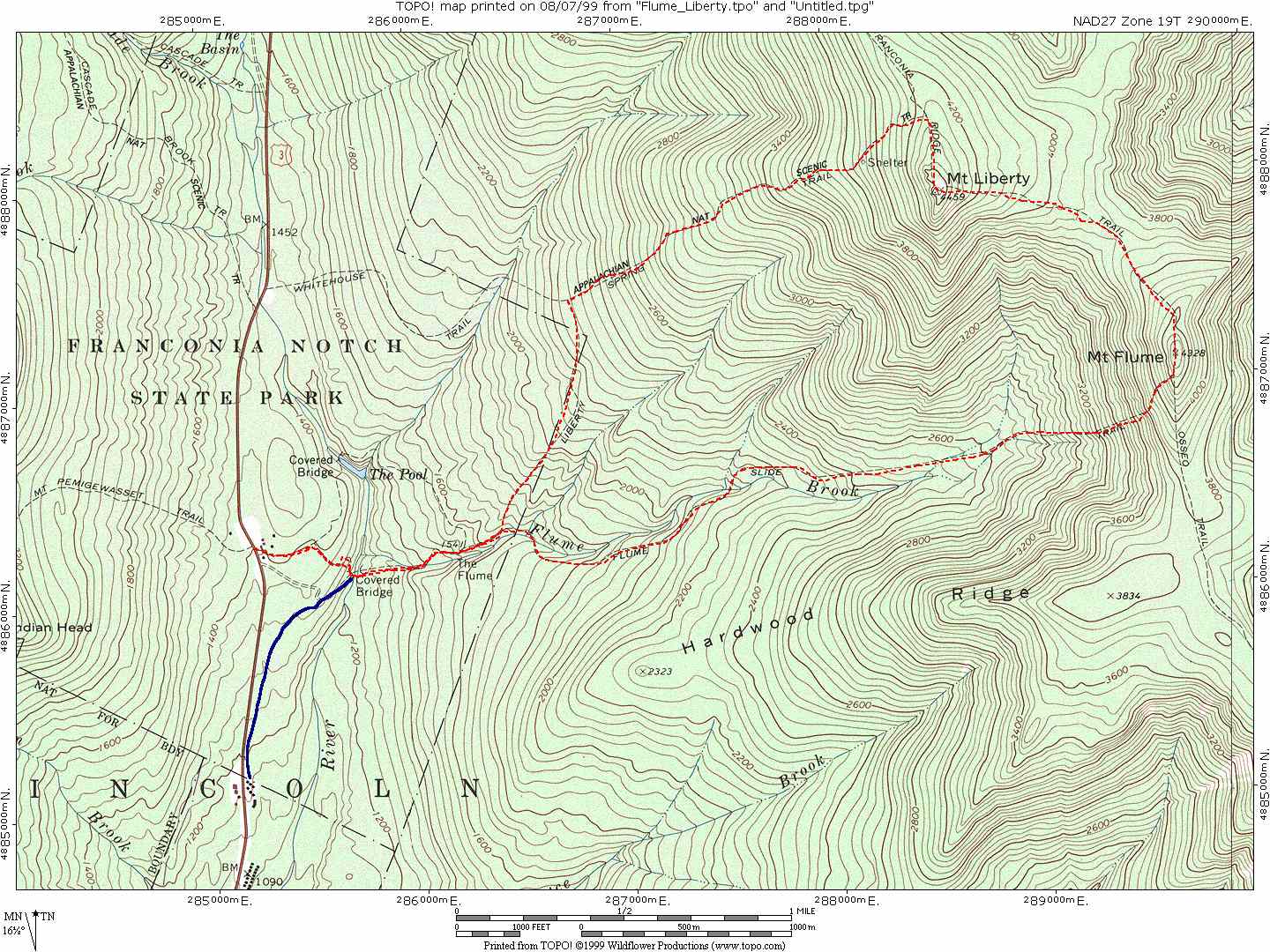
Click here to view a full size version of this map. This will open a new page and display a .jpg image that is 1080 x 1440 in size. (That means probably alot larger than your screen). It is a low quality .jpg file which means it is only suitable for screen display ... it look like garbage on a printer. If you would like a full color, high quality, suitable for printing and use with a compass copy of this map, email us at maps@hike-nh.com and we will e-mail you a copy. Be sure to indicate the map you want somewhere in your e-mail. Please note that the high quality map file is 2.2MB in size!
Click here to view the full size elevation profile of this hike. This will also open in a new page and display a 1141 x 211 .gif image. This image is suitable for printing. Note the flat part of the hike at the start and the quick, steep uphill. Then notice the long steady downhill.
Chris Oberg & Robert Havasy
Hike-NH.com